While investigating Johnson Creek, The Conservancy Initiative has learned more disturbing news. (See the picture below of the Trout Stream). Based on the turbidity (i.e. - the quality of being cloudy, opaque, or thick with suspended matter) and level of suspended solids observed in the runoff from the landfill, the soil erosion and sediment control efforts of the landfill are not effective. A sampling team from EGLE confirmed that the level of turbidity observed on July 24th is likely an issue for aquatic life.
Landfill discharge mixes with Johnson creek
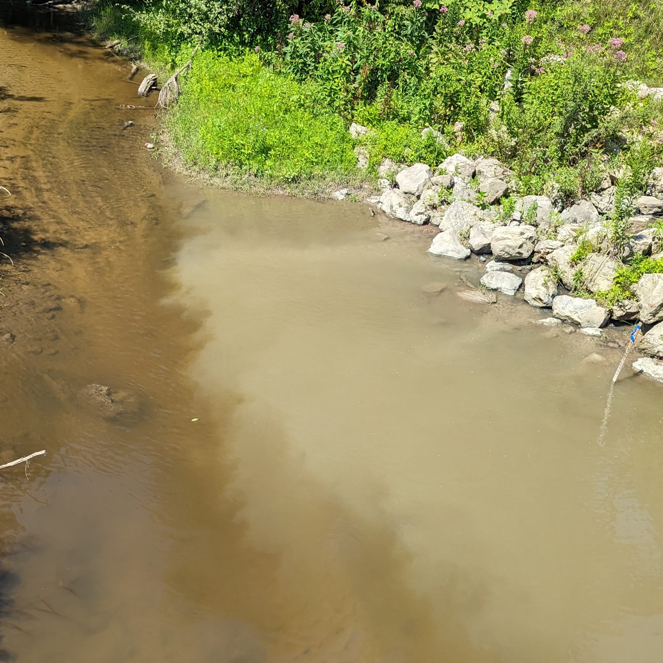
The dark brown water on the left side of the picture is the main artery of Johnson Creek at Ridge Road. The water is clear, and the dark brown color is the creek bottom. The turbid, light brown, sediment-laden water on the right side is an unnamed tributary from Arbor Hills Landfill. The water is clouded by suspended solids. Remember, this is a Trout Stream. Would this be acceptable in the AuSable, Pine, or Grand Rivers ….… Aquatic life cannot thrive in this water.
Johnson Creek does not meet water quality standards for a cold-water trout stream as it does not consistently maintain great enough Dissolved Oxygen (D.O.) levels. EGLE published a roadmap to correct the low D.O. in Johnson Creek and concluded that Suspended Solids are the pollutant of concern for D.O. Suspended Solid loads will need to be reduced by 85% to allow Johnson Creek to achieve the D.O. standards designated for a cold water stream[1].

Fig 2 - EGLE’s dissolved oxygen test equipment in Johnson Creek. Testing is being conducted for 14 days.
On July 24th, a team from EGLE performed testing of the dissolved oxygen in the creek and was troubled by the level of turbidity they observed from an unnamed tributary. With the help of The Conservancy Initiative, the unnamed tributary and the turbid water were traced back to the Arbor Hills Landfill[2]. The EGLE team returned several days later to perform a study on the effect of the sediment deposited on the creek bottom on the dissolved oxygen levels. The results of both studies are pending.
TCI sampled the water from the unnamed tributary and allowed it to settle for several hours. The solids settled out and the remaining water was clear, with a slight brown color indicating the entrainment of the solids could be controlled with standard soil erosion techniques (silt barriers, hay bales, catchment basins, detention ponds, etc.).


For the past several weeks The Conservancy Initiative has been tracing the “Unnamed Tributary’ of Johnson Creek that the Arbor Hills uses to drain the stormwater runoff from the landfill site. We have been investigating the “best locations” for our continuing PFAS testing. (We will update Johnson Creek PFAS testing in a future post). On July 24th, we unexpectantly met the EGLE sampling team trying to locate the source of the turbid water they found in Johnson Creek. It turns out we were basically tracing the same stream. The location where the unnamed tributary meets Johnson Creek can be observed just west of the Ridge Road bridge over Johnson Creek.

Locaction of Unnamed Tributary
It appears the sampling crew from EGLE stumbled upon a significant source of the dissolved oxygen issues in Johnson Creek. Now we need the landfill and regulators to step up and fix the issue. Remember, this is the same water that contains PFOS chemicals above Water Quality Standards.
The turbid stormwater discharges containing PFAS chemicals (more testing is planned) are adjacent to the MITech development along 5 Mile Road in both Northville and Plymouth Townships. $10 Million has been allocated to improve 5 Mile Road, property along 5 Mile Road is being cleared for development, and zoning designations along Ridge Road are being reviewed.
All this activity in Johnson Creek is central to the area targeted for a ~$6 Million Great Lakes Restoration Initiative project to improve the creek banks and make improvements to restore aquatic life in the creek. The project is scheduled to begin in 2024. It would be crazy to invest millions of taxpayers' dollars to restore the creek while a profitable corporation is damaging it.
Developers and Home Owner Associations in Northville Township are required to maintain their stormwater detention ponds and use standard soil erosion practices to prevent soil erosion during significant excavation activities. Detention ponds and stormwater catch basins are maintained to allow the settling and removal of solids before entering township or county drains. Erosion and sediment control standards must be enforced at the Arbor Hills Landfill and all developments planned for the MITech corridor to protect Johnson Creek.
Stay tuned for more updates on Johnson Creek.


[1] Total Maximum Daily Load for Dissolve Oxygen for Johnson Creek, Wayne and Washtenaw Counties, Michigan Department of Environmental Quality, Water Bureau, August 2007
[2] The unnamed tributary meets Johnson Creek just west of Ridge Road at the Ridge Road bridge over Johnson Creek. The EGLE sampling crew may dye-check the unnamed tributary in the future to confirm this finding.